Copper Kettle
Snapshot
| Location: | British Columbia, Canada |
| Ownership: | 100% owned |
| Deposit Type: | Cu-Mo-Au, Porphyry Bulk Tonnage Potential |
| Primary Minerals: | Copper, Molybdenum and Gold |
| Stage: | Advanced Greenfields |
Overview
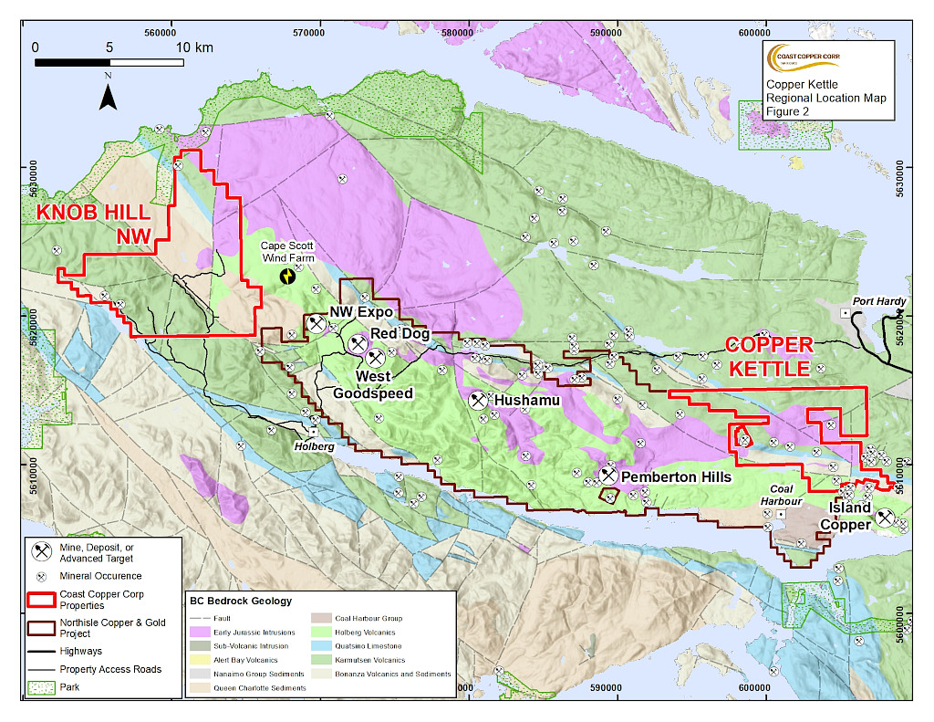
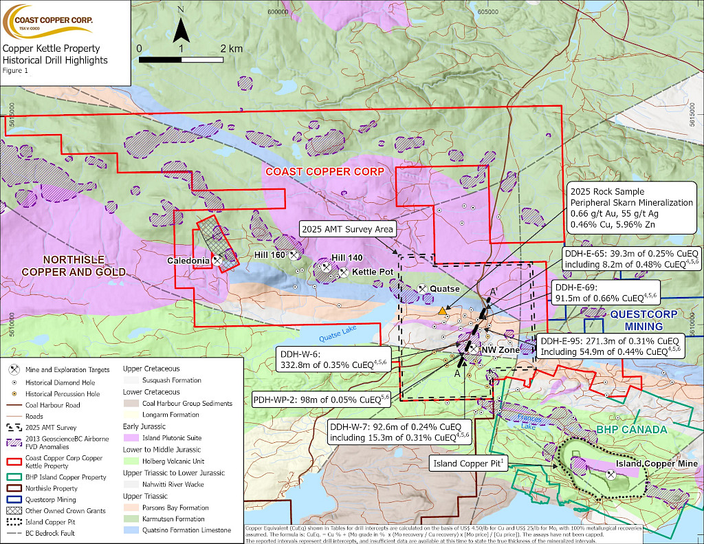
The Copper Kettle property is located on Northern Vancouver Island between the past producing Island Copper Mine and the Northisle Copper and gold Inc. North Island project1. The 5,225 ha property hosts the NW Zone, one of the six genetically related Jurassic calc-alkaline porphyry systems that form the “Island Copper Cluster” which occupies a 10 km long structural-magnetic anomaly with the NW Zone being the only member located outside BHP’s Island Copper mining lease2. From 1983 to 1989 BHP drilled 31 diamond holes (9,072 meters (“m”)) and 10 percussion holes (789.5 m), outlining a buried system 1.8 km long and 800 m wide. Seventeen drillholes returned significant copper and molybdenum values; nine of which ended in mineralization, confirming this system remains open to depth (see news release dated September 8, 2025). Highlights from BHP’s previous drilling include 277.4 m assaying 0.20% Cu and 0.018% Mo in hole E-64, 91.5 m assaying 0.57% Cu and 0.017% Mo in hole E-69 and 88.4 m assaying 0.38% Cu and 0.029% Mo in hole W-6 3
Geology
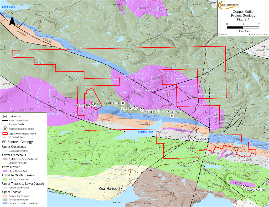
The Copper Kettle Property hosts the Northwest Zone Cu + Mo Porphyry target plus localised high grade Au + Ag + Cu + Pb + Zn skarn targets. Copper Kettle forms part of the renowned Island Copper Cluster (“ICC”) on northern Vancouver Island, which hosts Northisle Copper and Gold’s North Island Project. The ICC comprises six genetically related Jurassic-age (175 Ma) calc-alkaline porphyry systems. These intrude co-magmatic Bonanza Group arc volcanics and the underlying Vancouver Group strata. The ICC includes five porphyry Cu-gold (“Au”)-Mo systems (Island Copper, Bay Lake, G Zone, Red Island and Rupert Inlet) and one distinct porphyry Cu-Mo system—the NW Zone. The NW Zone is notable for its stronger skarn affinity in Quatsino limestone and Parson Bay Formation sediments, possessing higher Mo:Cu ratios, and contains subordinate gold. Island Copper, the only mined cluster member to date (operated from 1971 to 1995 by Utah Mines and later BHP), produced approximately 345–367 million tonnes of ore at average grades of 0.41% Cu, 0.017% Mo, 0.19 g/t Au, and 1.4 g/t silver (“Ag”), as well as significant rhenium. All six systems are characterized by multiphase rhyodacitic porphyry intrusions and zoned alteration patterns. These include an early Na-Fe-Ca ± magnetite- amphibole core overprinted by K-silicate biotite-magnetite-chalcopyrite, transitional chlorite-magnetite, and peripheral propylitic alteration. Mineralization occurs as disseminated and veinlet chalcopyrite-molybdenite-pyrite within reactive volcanic hosts.
From 1983 to 1989 BHP drilled 31 diamond holes (9,072 meters (“m”) and 10 percussion holes (789.5 m) at the Northwest Zone. The drilling outlined a buried system 1.8 km long and 800 m wide. Seventeen drillholes returned significant copper and molybdenum values; nine of which ended in mineralization, confirming this system remains open to depth. Highlights from BHP’s previous drilling include 277.4 m assaying 0.20% Cu and 0.018% Mo in hole E-64, 91.5 m assaying 0.57% Cu and 0.017% Mo in hole E-69 and 88.4 m assaying 0.38% Cu and 0.029% Mo in hole W-6. The Northwest Zone is like the others in the ICC with rhyodacite – dacite Cu + Mo mineralized dikes intruding through the host rock.
Work completed by Coast Copper
2025 Coast Copper Surface Field Work Expands Target Area
Recent fieldwork expanded historical anomalies:
- Confirmed an untested 800 m × 400 m Cu-in-soil anomaly (>200 ppm) Cu; peaks at 1,800 ppm) north of historical drill sites;
- Collected rock samples assaying up to 2.21%, 2.09%, and 1.86% Cu across a 5 km west-northwest stretch; and
- Discovered a new polymetallic skarn target, with assays reaching 0.46% Cu, 0.66 g/t Au, 55 g/t Ag, 7.53% Pb, and 5.96% Zn; soils contained up to 2,842 ppm Cu.
These results indicate significant untested lateral and depth potential, largely hidden beneath glacial cover.
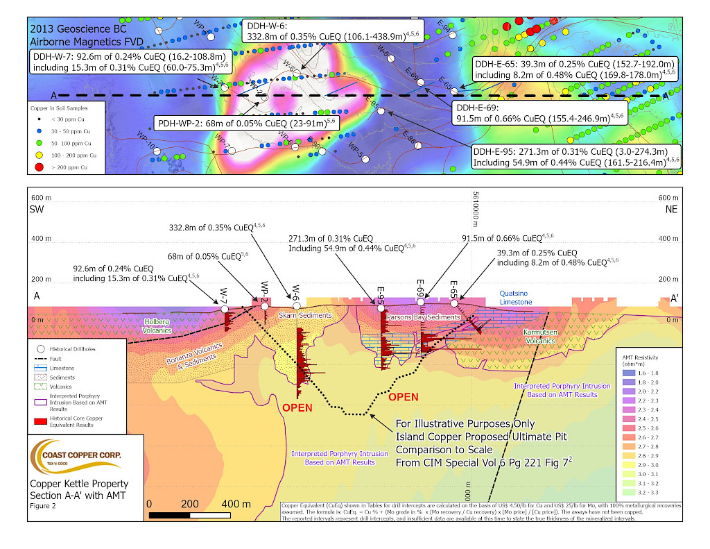
December 2025 AMT Survey Highlights
The 54-station AMT survey (spaced at 500 m) spanning 14 km² revealed:
- A shallow conductive layer linked to known Cu-Mo mineralization within sediments;
- A larger resistive body under historic drilling, interpreted as a possible intrusive source; and
- Evidence that past drilling in the 1980s only addressed a limited portion of the broader system.
Results integrated with the 2012 Geoscience BC magnetic survey uphold the hypothesis of a sizable, mostly untested intrusive complex beneath the NW Zone.
Coast Copper news releases related to this Property
Footnotes
1. This webpage may contain information about adjacent properties on which Coast Copper has no right to explore or mine. Investors are cautioned that mineral deposits on adjacent properties are not indicative of mineral deposits on the Company’s properties.
2. Perello J.A., Fleming J.A., O’Kane K.P., Burt P.D., Clakre G.A., Himes M.D. and Reeves A.T. (1995) Porphyry copper-gold- molybdenum deposits in the Island Copper Cluster, northern Vancouver Island, British Columbia: CIM Special Volume 46, Part 2, p. 214-238.
3. Historical information, maps or figures contained in this release regarding the Property or adjacent properties cannot be relied upon as the Company’s QP, as defined under NI-43-101 has not prepared nor verified the historical information.